Skip to content
A Mysterious Square Lake and The ‘Lost’ Bunker Site (Cedarhill, Ontario)

- Recently declassified documents reveal that the original planning for protected facilities (from which small numbers of elected and selected government officials could ensure continuity of legitimate federal government) involved 15 potential sites in the area about 30 to 70 kilometers west and southwest of Ottawa.
- Original planning seriously considered two, (or possibly three) of these locations for federal officials and along with another devoted to telecommunications. Of the main sites, all but sites #1, #7 and #8 were eliminated quite early in the selection process. Site #1 (Carp), Site #7 (Almonte-Cedarhill area), and Site #8 (Galetta area) were evaluated as to their suitability for ‘executive’ structures that would have sheltered about 300 people for up to 30 days. Site #15 (location not known) was to be a ‘comms’ facility. It appears the planners then decided to split telecommunications capabilities between two other structures and increase the capacity of each ‘executive’ structure to 410 people. Site #15 was then ‘abandoned’ (for the moment!).
- Work actually began at two of the other sites (Carp and Almonte-Cedarhill). Costs were rising because of lack of experience building such complex structures. Perhaps for that reason or because of a serious excavation flooding problem encountered at the Almonte-Cedarhill Site, that site was also abandoned (after most of the foundation had already been excavated). Remaining efforts (and funds) were then concentrated on the Carp site.
- For reasons unknown, many felt that the Carp Site was not the best choice. Also it appears that the idea of having a separate ‘comms’ transmission facility was resurrected, suggesting that the final location of the constructed mini-bunker (at Richardson just east of Perth) was its originally intended Site #15 location.
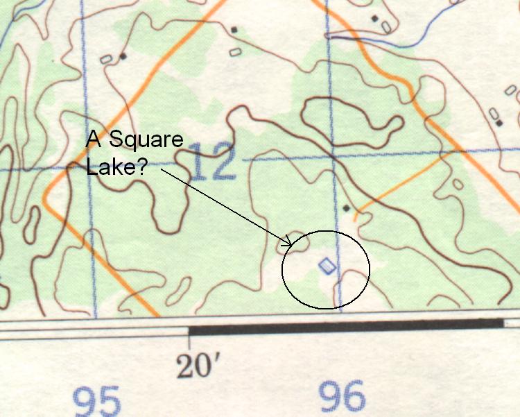
- Site #7 (the Almonte-Cedarhill location)? – Well it seems that it has become a permanent topographic feature, a ‘square lake’, sufficiently visible from aerial surveys that it began to appear as a distinct feature on topographic maps as early as 1969!
- Copy and paste the following to see Google Map of the abandoned site. http://maps.google.ca/maps?hl=en&ll=45.251809,-76.324854&spn=0.02568,0.076818&z=14 Or follow this link. It is the diamond-shaped hole with a water path directly south. Switch to satellite view and zoom in twice to get a better view. The path is the excavation ramp. Below that is a pile of tailings which (having visited the site twice) I calculate to have a volume equivalent to the estimated volume of the pit. The pit is almost exactly 200 ft on a side which would be the same excavated size of the Carp site.
- All around the area are bits and pieces of evidence of DND / contractor activity (which is now of course over 60 years old. Barbed wire, truck maintenance pits, warning signs,etc. abound. The straight-sided pit is full of water (and leaches!).
- Various readings suggest it was abandoned because of the discovery the location was in a hanging water table, but the problem may have just been cost over-runs, It is believed that the intention was to have two equivalent sites of about 400+ occupants each and that the Bank of Canada Vault would have been integral to the Cedar Hill facility. When the site was abandoned the BoC vault was relocated to be an annex connected by a tunnel to the Carp facility which doesn’t make any sense from the designed blast integrity of the the Carp facility at all!
coldwarincanada2025-11-02T17:41:51-05:00
Share This Story, Choose Your Platform!
Page load link


